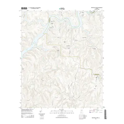
2014 Map of Burchfield Store
USGS Topo · Published 2014About this map
The Black Warrior River and Bankhead Lake dominate this landscape on the border of Tuscaloosa and Jefferson counties. In this 2014 survey, the winding waterway is defined by its deep bends, including Dunns Bend and Nancy Ann Bend, which separate heavily dissected ridges like Pumpkin Ridge and Brown Ridge. The map identifies small communities and landmarks that reveal the area's rural character and social geography, such as the namesake Burchfield Store, Providence, and Bull City.
Find a feature on this map
83 named features on this map. Tap any name to fly to it.
Don’t see what you’re looking for? This feature index may not catch every label — zoom into the map to look around manually.
Map Details
Editions of this 2014 Burchfield Store Map
This is the sole edition of this map. No revisions or reprints were ever made.
Other maps of this area

1893 · Jasper
USGS Topo · 1:125,000

1899 · Brookwood
USGS Topo · 1:125,000

1927 · Adger
USGS Topo · 1:48,000

1929 · Searles
USGS Topo · 1:48,000

1932 · Yolande
USGS Topo · 1:62,500

1934 · Searles
USGS Topo · 1:62,500

1935 · Port Birmingham
USGS Topo · 1:48,000

1935 · Yolande
USGS Topo · 1:62,500

1938 · Port Birmingham
USGS Topo · 1:62,500

1949 · Tutwiler School
USGS Topo · 1:24,000