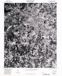
1980 Map of Burlington
USGS Topo · Published 1983About this map
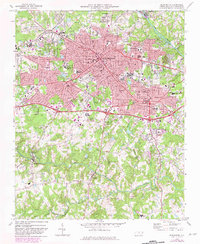
Burlington and Graham appear in dense detail during the early 1980s, showcasing the suburban expansion and industrial footprint of these Piedmont North Carolina communities. This orthophotoquad, derived from 1980 aerial photography, provides a literal visual record of land use, from the tightly packed residential blocks and commercial corridors of the urban centers to the winding watercourses that define the regional geography. The confluence of Stony Creek and the Haw River anchors the northeastern corner of the map, while the southern reaches transition into more fragmented woodlands and agricultural clearings near Bellemont. Local historians can observe the paths of Alamance Creek and Big Alamance Creek as they meander through the landscape, alongside the evocatively named Stinking Quarter Creek. The map serves as a precise baseline for tracing the growth of Alamance County's infrastructure and the preservation of its natural drainage systems.
Find a feature on this map
8 named features on this map. Tap any name to fly to it.
Don’t see what you’re looking for? This feature index may not catch every label — zoom into the map to look around manually.
Map Details
Editions of this 1980 Burlington Map
This is the sole edition of this map. No revisions or reprints were ever made.
Historical Maps of Burlington Through Time
7 maps found