
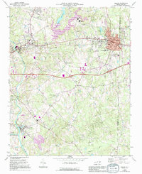
1969 Map of Mebane
USGS Topo · Published 1972About this map
Mebane and its immediate surroundings in Alamance and Orange Counties are defined by the convergence of the Southern railroad and the Haw River. This late-1960s landscape shows the expansion of Mebane southward from the rail line, with institutional footprints like South Mebane Sch and the Oakwood Cem well established. Further west, the Haw River settlement and Swepsonville sit along the river's path, where infrastructure such as a Filtration Plant and multiple Sewage Disposal sites indicate mid-century industrial and residential growth. Smaller communities like Hawfields and Melville remain more rural, anchored by local institutions such as Hawfields United Ch and the Phillips Chapel. The varied terrain is shaped by numerous tributaries including Back Creek and Meadow Creek, which flow toward the primary river corridor, alongside smaller impoundments like Quaker Creek Reservoir and Graham Lake.
Find a feature on this map
45 named features on this map. Tap any name to fly to it.
Don’t see what you’re looking for? This feature index may not catch every label — zoom into the map to look around manually.
Map Details
Editions of this 1969 Mebane Map
2 editions found
Other maps of this area

1953 · Raleigh
USGS Topo · 1:250,000

1953 · Greensboro
USGS Topo · 1:250,000

1954 · Greensboro
USGS Topo · 1:250,000

1954 · Raleigh
USGS Topo · 1:250,000

1962 · Greensboro
USGS Topo · 1:250,000

1966 · Greensboro
USGS Topo · 1:250,000

1967 · Cedar Grove
USGS Topo · 1:24,000

1968 · White Cross
USGS Topo · 1:24,000

1968 · Efland
USGS Topo · 1:24,000

1969 · Burlington
USGS Topo · 1:24,000