
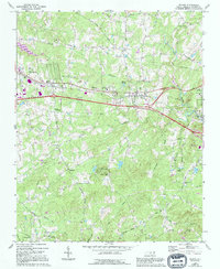
1968 Map of Efland
USGS Topo · Published 1970About this map
Efland serves as a central hub on this mid-century survey, positioned where the Southern Railway runs parallel to the developing corridor of Interstate 85. The landscape is defined by the headwaters of several significant drainages, including Sevenmile Creek and New Hope Creek, which carve through the Piedmont terrain. Small community centers such as Cheeks Crossroads and Miles show the enduring rural settlement patterns of Orange County, supported by a dense network of local institutions like the Efland-Cheeks Sch and numerous country churches, including Lebanon Ch and White Cross Ch. To the south, Camp Chestnut Ridge and the Efland Millpond represent the area's recreational and industrial heritage. The mapping detail captures a moment of transition as traditional agricultural life, evidenced by the many unnamed family cemeteries, begins to interface with modern infrastructure like the regional Pipeline and expanding highway systems.
Find a feature on this map
55 named features on this map. Tap any name to fly to it.
Don’t see what you’re looking for? This feature index may not catch every label — zoom into the map to look around manually.
Map Details
Editions of this 1968 Efland Map
2 editions found
Other maps of this area

1946 · Chapel Hill
USGS Topo · 1:24,000

1947 · Chapel Hill
USGS Topo · 1:31,680

1953 · Raleigh
USGS Topo · 1:250,000

1953 · Greensboro
USGS Topo · 1:250,000

1954 · Greensboro
USGS Topo · 1:250,000

1954 · Raleigh
USGS Topo · 1:250,000

1962 · Greensboro
USGS Topo · 1:250,000

1966 · Greensboro
USGS Topo · 1:250,000

1967 · Cedar Grove
USGS Topo · 1:24,000

1968 · White Cross
USGS Topo · 1:24,000