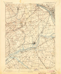
1893 Map of Burlington
USGS Topo · Published 1904About this map
The Delaware River serves as the central artery for this late 19th-century landscape, defining the boundary between Pennsylvania and New Jersey. The map reveals an intricate network of water-based infrastructure and industrial foundations, notably the Delaware and Raritan Canal Feeder and the Trenton Water Power Mill Race near Trenton. Commercial transit points such as Tullytown Wharf and Andalusia Wharf line the riverbanks, while historic river crossings like Dunks Ferry and Borton Landing highlight the era's reliance on ferries and landings.
Find a feature on this map
122 named features on this map. Tap any name to fly to it.
Don’t see what you’re looking for? This feature index may not catch every label — zoom into the map to look around manually.
Map Details
Editions of this 1893 Burlington Map
3 editions found

Other maps of this area

1888 · Bordentown
USGS Topo · 1:62,500

1888 · Pemberton
USGS Topo · 1:62,500

1888 · Mount Holly
USGS Topo · 1:62,500

1888 · Princeton
USGS Topo · 1:62,500

1890 · Lambertville
USGS Topo · 1:62,500

1890 · Doylestown
USGS Topo · 1:62,500

1890 · Burlington
USGS Topo · 1:62,500

1891 · Lambertville
USGS Topo · 1:62,500

1891 · Doylestown
USGS Topo · 1:62,500

1891 · Philadelphia
USGS Topo · 1:62,500