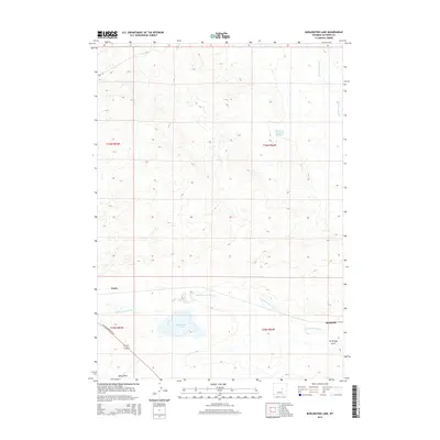
2015 Map of Burlington Lake
USGS Topo · Published 2015About this map
Burlington Lake lies at the heart of this high-plains landscape in Natrona County, where the high desert meets a series of critical drainage systems. The small settlements of Petrie and Bucknum serve as the primary markers of human habitation, situated along the southern edge of the map near the W US Highway 20-26 corridor. The geography is defined by the winding paths of Middle Fork Casper Cr and N Fork Casper Cr, which carve through the terrain and feed essential water sources like Roseberry Reservoir Number 2. These water bodies and ephemeral features such as Selby Draw and Tie Bridge Gulch illustrate the hydrologic patterns of the Wyoming basin, where every creek and reservoir plays a vital role in supporting the surrounding ranching and transport networks.
Find a feature on this map
14 named features on this map. Tap any name to fly to it.
Don’t see what you’re looking for? This feature index may not catch every label — zoom into the map to look around manually.
Map Details
Editions of this 2015 Burlington Lake Map
This is the sole edition of this map. No revisions or reprints were ever made.
Other maps of this area

1950 · Emigrant Gap NE
USGS Topo · 1:24,000

1951 · Emigrant Gap NW
USGS Topo · 1:24,000

1951 · Reid Canyon
USGS Topo · 1:24,000

1955 · Arminto
USGS Topo · 1:250,000

1955 · Casper
USGS Topo · 1:250,000

1958 · Casper
USGS Topo · 1:250,000

1958 · Arminto
USGS Topo · 1:250,000
1960 · Emigrant Gap NE
USGS Topo · 1:24,000

1962 · Arminto
USGS Topo · 1:250,000

1962 · Casper
USGS Topo · 1:250,000