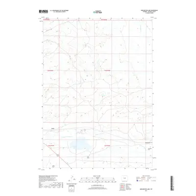
2017 Map of Burlington Lake
USGS Topo · Published 2017About this map
Burlington Lake and the drainages of the Casper Creek system anchor this high-plains landscape in Natrona County. The map details a region defined by its seasonal watercourses and drainage patterns, including Middle Fork Casper Cr and N Fork Casper Cr, which carve through the terrain alongside features like Selby Draw and Tie Bridge Gulch. The sparse settlement pattern is concentrated at Petrie and Bucknum, points along the transportation corridor that traverses the southern half of the quadrangle. High-altitude cattle country and sagebrush steppe are implied by the presence of Co Rd 126 and the vast stretches of sectioned land, reflecting the enduring legacy of the Public Land Survey System across the Wyoming basin. This document provides a clear view of the rural infrastructure and natural landmarks essential for navigating and managing this part of the state.
Find a feature on this map
14 named features on this map. Tap any name to fly to it.
Don’t see what you’re looking for? This feature index may not catch every label — zoom into the map to look around manually.
Map Details
Editions of this 2017 Burlington Lake Map
This is the sole edition of this map. No revisions or reprints were ever made.
Other maps of this area

1950 · Emigrant Gap NE
USGS Topo · 1:24,000

1951 · Emigrant Gap NW
USGS Topo · 1:24,000

1951 · Reid Canyon
USGS Topo · 1:24,000

1955 · Arminto
USGS Topo · 1:250,000

1955 · Casper
USGS Topo · 1:250,000

1958 · Casper
USGS Topo · 1:250,000

1958 · Arminto
USGS Topo · 1:250,000
1960 · Emigrant Gap NE
USGS Topo · 1:24,000

1962 · Arminto
USGS Topo · 1:250,000

1962 · Casper
USGS Topo · 1:250,000