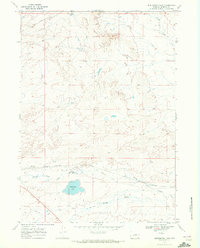
1968 Map of Burlington Lake
USGS Topo · Published 1972About this map
Middle Fork Casper Creek meanders through this portion of Natrona County, marking a landscape defined by the convergence of drainage systems and early transportation corridors. The map highlights the Old Railroad Grade running parallel to the newer Burlington Northern line, offering a clear record of changing rail alignments in the high plains. The presence of Burlington Lake 5496 and Bridge Gulch suggests a terrain shaped by seasonal water flow and irrigation potential. Technical infrastructure is visible through a prominent Pipeline and scattered resource exploration markers such as various Drill Hole and Well sites. This 1968 field-checked survey by the Geological Survey captures the area just as modern energy and transport footprints were being established over older territorial pathways like Selby Draw.
Find a feature on this map
10 named features on this map. Tap any name to fly to it.
Don’t see what you’re looking for? This feature index may not catch every label — zoom into the map to look around manually.
Map Details
Editions of this 1968 Burlington Lake Map
This is the sole edition of this map. No revisions or reprints were ever made.
Other maps of this area

1950 · Emigrant Gap NE
USGS Topo · 1:24,000

1951 · Emigrant Gap NW
USGS Topo · 1:24,000

1951 · Reid Canyon
USGS Topo · 1:24,000

1955 · Arminto
USGS Topo · 1:250,000

1955 · Casper
USGS Topo · 1:250,000

1958 · Casper
USGS Topo · 1:250,000

1958 · Arminto
USGS Topo · 1:250,000
1960 · Emigrant Gap NE
USGS Topo · 1:24,000

1962 · Arminto
USGS Topo · 1:250,000

1962 · Casper
USGS Topo · 1:250,000