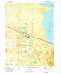
1972 Map of Burmester
USGS Topo · Published 1974About this map
Great Salt Lake dominates the eastern edge of this coastal landscape, where the shifting shoreline meets the Alkali or Mud flats of the northern Tooele Valley. The settlement of Burmester serves as a small hub between the industrial Salt Evaporators and the extensive Western Pacific railroad line that cuts across the salt plains. The map reveals an intricate network of water management and resource extraction, evidenced by numerous Borrow Pits and several Flowing Wells dotting the valley floor.
Find a feature on this map
22 named features on this map. Tap any name to fly to it.
Don’t see what you’re looking for? This feature index may not catch every label — zoom into the map to look around manually.
Map Details
Editions of this 1972 Burmester Map
This is the sole edition of this map. No revisions or reprints were ever made.
Other maps of this area

1885 · Tooele Valley
USGS Topo · 1:250,000

1953 · Tooele
USGS Topo · 1:250,000

1955 · Timpie
USGS Topo · 1:62,500

1955 · Mills Junction
USGS Topo · 1:24,000

1955 · Burmester
USGS Topo · 1:24,000

1955 · Grantsville
USGS Topo · 1:24,000

1955 · Tooele
USGS Topo · 1:250,000

1955 · Tooele
USGS Topo · 1:24,000

1968 · Plug Peak SE
USGS Topo · 1:24,000

1968 · Corral Canyon
USGS Topo · 1:24,000