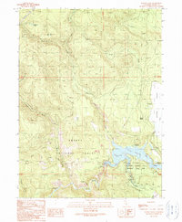
1990 Map of Burney Falls
USGS Topo · Published 1990About this map
Mcarthur Burney Falls Memorial State Park serves as the centerpiece of this terrain where the Pit River meets Lake Britton. The map documents the complex engineering of the Pit No 3 Dam and its associated Spillway Elevation 2733, which fundamentally altered the local hydrology. North of the water, the landscape transitions into the Shasta National Forest, characterized by numerous named drainages like Rock Creek and North Fork Clark Creek.
Find a feature on this map
43 named features on this map. Tap any name to fly to it.
Don’t see what you’re looking for? This feature index may not catch every label — zoom into the map to look around manually.
Map Details
Editions of this 1990 Burney Falls Map
This is the sole edition of this map. No revisions or reprints were ever made.
Other maps of this area

1886 · Lassen Peak
USGS Topo · 1:250,000

1886 · Modoc Lava Bed
USGS Topo · 1:250,000

1892 · Modoc Lava-Bed
USGS Topo · 1:250,000

1892 · Lassen Peak
USGS Topo · 1:250,000

1894 · Lassen Peak
USGS Topo · 1:250,000

1932 · Bartle
USGS Topo · 1:96,000

1935 · Burney
USGS Topo · 1:96,000

1939 · Burney
USGS Topo · 1:125,000

1939 · Bartle
USGS Topo · 1:125,000

1954 · Alturas
USGS Topo · 1:250,000