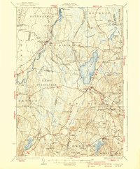
1926 Map of Burnham
USGS Topo · Published 1940About this map
Unity Pond anchors this central Maine landscape, where the rural townships of Burnham, Unity, and Thorndike meet. Surveyed in the 1920s, the map documents a transition in transportation, showing the intersection of the Maine Central Railroad and the specialized Waterville and Farmington (Narrow Gage) line near Albion. The area is densely settled with family-named crossroads like Twitchell Corner and Reynolds Corner, reflecting a mature agrarian economy.
Find a feature on this map
112 named features on this map. Tap any name to fly to it.
Don’t see what you’re looking for? This feature index may not catch every label — zoom into the map to look around manually.
Map Details
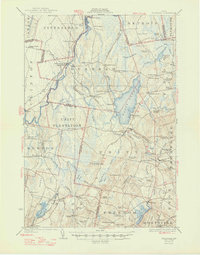
Editions of this 1926 Burnham Map
3 editions found
Other maps of this area

1892 · Waterville
USGS Topo · 1:62,500

1893 · Vassalboro
USGS Topo · 1:62,500

1898 · Vassalboro
USGS Topo · 1:62,500

1913 · Skowhegan
USGS Topo · 1:62,500

1915 · Belfast
USGS Topo · 1:62,500

1916 · Liberty
USGS Topo · 1:62,500

1917 · Belfast
USGS Topo · 1:62,500

1926 · Burnham
USGS Topo · 1:62,500

1930 · Pittsfield
USGS Topo · 1:48,000

1931 · Stetson
USGS Topo · 1:48,000