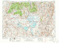
1955 Map of Burns
USGS Topo · Published 1972About this map
Malheur Lake and Harney Lake dominate the high desert basin of this 1970 revision, anchoring the sprawling Malheur National Wildlife Refuge. The regional hub of Burns and the industrial neighbor Hines serve as the primary population centers, where a prominent lumber mill indicates the importance of the timber industry drawn from the surrounding Ochocoo National Forest and Malheur National Forest. The map captures a high-elevation landscape defined by volcanic features like Diamond Craters and massive ranges such as Steens Mountain. Transportation is centered on the intersection of Us 20 and Us 395, while the Union Pacific railroad corridor extends east through Crane toward Juntura. Agricultural development is noted at the State experimental station, reflecting the era's focus on land management in the arid Harney Basin.
Find a feature on this map
81 named features on this map. Tap any name to fly to it.
Don’t see what you’re looking for? This feature index may not catch every label — zoom into the map to look around manually.
Map Details
Editions of this 1955 Burns Map
3 editions found
Other maps of this area

1908 · Ironside Mountain
USGS Topo · 1:125,000

1932 · Dayville
USGS Topo · 1:125,000

1936 · Dayville
USGS Topo · 1:125,000

1955 · Jordan Valley
USGS Topo · 1:250,000

1955 · Crescent
USGS Topo · 1:250,000

1955 · Klamath Falls
USGS Topo · 1:250,000

1955 · Baker
USGS Topo · 1:250,000

1955 · Bend
USGS Topo · 1:250,000

1955 · Burns
USGS Topo · 1:250,000

1955 · Canyon City
USGS Topo · 1:250,000