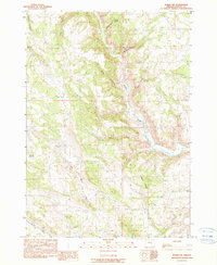
1990 Map of Burns NW
USGS Topo · Published 1990About this map
The Silvies River winds through the high desert of Harney County, carving a narrow valley through a landscape defined by seasonal drainages and cattle country. This 1990 provisional survey documents a network of water management features essential to ranching in the Oregon interior, including the Skull Creek Reservoir, Green Flat Reservoir, and Shoeffer Reservoir. These man-made catchments, paired with natural sources like Cherry Spring, illustrate the careful orchestration of water in an arid environment.
Find a feature on this map
15 named features on this map. Tap any name to fly to it.
Don’t see what you’re looking for? This feature index may not catch every label — zoom into the map to look around manually.
Map Details
Editions of this 1990 Burns NW Map
This is the sole edition of this map. No revisions or reprints were ever made.
Other maps of this area

1955 · Burns
USGS Topo · 1:250,000

1958 · Burns
USGS Topo · 1:250,000

1959 · Burns
USGS Topo · 1:250,000

1959 · West Myrtle Butte
USGS Topo · 1:62,500

1959 · Sawtooth Creek
USGS Topo · 1:62,500

1960 · Burns
USGS Topo · 1:62,500

1960 · Burns
USGS Topo · 1:24,000

1975 · Burns
USGS Topo · 1:24,000

1981 · Sage Hen Hill
USGS Topo · 1:24,000
1981 · Holmes Canyon
USGS Topo · 1:24,000