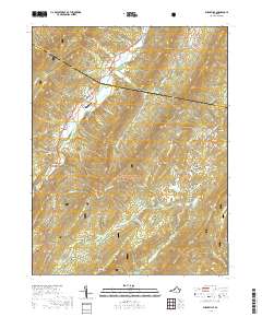
2019 Map of Burnsville
USGS Topo · Published 2019About this map
Bolar and Burnsville anchor this 2019 study of the high ridges and deep valleys along the Highland Co Bath Co line. The terrain is dominated by parallel mountain ranges, including Jack Mountain, Warm Springs Mtn, and Back Creek Mtn, which frame the agricultural and residential corridors of Big Valley and Little Valley. The Jackson River winds through the northwestern corner, joined by tributaries such as Stony Run and Mill Run. For those researching local families, several small burial grounds are marked, including Stony Run Cem, Cleek Cem, and Big Valley Cem. This landscape within the George Washington National Forest remains characterized by its traditional rural structure, where travel is dictated by natural passes like Bolar Gap and the network of forest roads and state routes that connect isolated mountain hollows.
Find a feature on this map
60 named features on this map. Tap any name to fly to it.
Don’t see what you’re looking for? This feature index may not catch every label — zoom into the map to look around manually.
Map Details
Editions of this 2019 Burnsville Map
This is the sole edition of this map. No revisions or reprints were ever made.
Other maps of this area

1901 · Monterey
USGS Topo · 1:125,000

1922 · Cass
USGS Topo · 1:48,000

1923 · Warm Springs
USGS Topo · 1:48,000

1924 · Cass
USGS Topo · 1:62,500

1926 · Warm Springs
USGS Topo · 1:62,500

1930 · Warm Springs Run
USGS Topo · 1:24,000

1933 · Warm Springs Run
USGS Topo · 1:31,680

1941 · Monterey
USGS Topo · 1:62,500

1944 · Monterey
USGS Topo · 1:62,500

1946 · Warm Springs
USGS Topo · 1:62,500