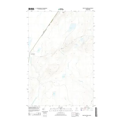
2014 Map of Burntland Pond
USGS Topo · Published 2014About this map
The international border between Maine and Quebec bisects this terrain, where the northern reaches of Aroostook County meet the settlement of Lac Frontiere. The landscape is defined by an intricate network of water bodies, including Burntland Pond, Presley Lake, and the winding course of the Northwest Branch Saint-John River. High ground is anchored by Sugarloaf Mtn, providing a prominent landmark above the surrounding wetlands and ponds like Beaver Pond and Mud Pond. Remote access through this heavily wooded region is facilitated by routes such as Number 1 Rd and Depot Rd. The presence of Burntland Brook and Oak Brook feeding into the river system illustrates the hydrologic character of this borderland area during the early twenty-first century.
Find a feature on this map
16 named features on this map. Tap any name to fly to it.
Don’t see what you’re looking for? This feature index may not catch every label — zoom into the map to look around manually.
Map Details
Editions of this 2014 Burntland Pond Map
This is the sole edition of this map. No revisions or reprints were ever made.
Other maps of this area

1954 · Presque Isle
USGS Topo · 1:250,000

1955 · Depot Lake
USGS Topo · 1:62,500

1955 · Beaver Pond
USGS Topo · 1:62,500

1958 · Presque Isle
USGS Topo · 1:250,000

1960 · Presque Isle
USGS Topo · 1:250,000

1962 · Quebec
USGS Topo · 1:250,000

1976 · Depot Lake
USGS Topo · 1:24,000
1977 · St. Adalbert
USGS Topo · 1:24,000
1977 · Burntland Pond
USGS Topo · 1:24,000
1986 · Mary L Pond
USGS Topo · 1:24,000