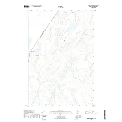
2018 Map of Burntland Pond
USGS Topo · Published 2018About this map
The Canada-United States border cuts diagonally through this remote northern landscape, where the settlement of Lac Frontière sits at the edge of the international line. This 2018 survey reveals a terrain defined by complex hydrology and logging access roads like Number 1 Rd and Depot Rd. The southern portion of the map is dominated by the winding path of the Northwest Branch Saint John River, while higher elevations rise toward Sugarloaf Mtn in the north. The area is dotted with numerous water bodies including Burntland Pond, Presley Lake, and Beam Pond, suggesting a region shaped by timber interests and seasonal water flow. The inclusion of French-named features such as Rivière Leverrier and Petit Ruisseau Maringouin highlights the cultural intersection at the Maine-Quebec boundary, where local commerce and geography have long been tied to the Saint John River watershed.
Find a feature on this map
17 named features on this map. Tap any name to fly to it.
Don’t see what you’re looking for? This feature index may not catch every label — zoom into the map to look around manually.
Map Details
Editions of this 2018 Burntland Pond Map
This is the sole edition of this map. No revisions or reprints were ever made.
Other maps of this area

1954 · Presque Isle
USGS Topo · 1:250,000

1955 · Depot Lake
USGS Topo · 1:62,500

1955 · Beaver Pond
USGS Topo · 1:62,500

1958 · Presque Isle
USGS Topo · 1:250,000

1960 · Presque Isle
USGS Topo · 1:250,000

1962 · Quebec
USGS Topo · 1:250,000

1976 · Depot Lake
USGS Topo · 1:24,000
1977 · St. Adalbert
USGS Topo · 1:24,000
1977 · Burntland Pond
USGS Topo · 1:24,000
1986 · Mary L Pond
USGS Topo · 1:24,000