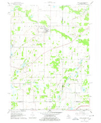
1961 Map of Burr Oak
USGS Topo · Published 1978About this map
The village of Burr Oak serves as the focal point for this 1961 survey, situated along the New York Central rail line in southern Michigan. The landscape is a network of agricultural land and water features, where the Prairie River and Fawn River meander through St. Joseph and Branch counties. Local history and genealogy are well-represented by several burial grounds, including the Dutch Settlement Cem, Esh Cem, and Freedom Cem, which anchor the rural community.
Find a feature on this map
46 named features on this map. Tap any name to fly to it.
Don’t see what you’re looking for? This feature index may not catch every label — zoom into the map to look around manually.
Map Details
Editions of this 1961 Burr Oak Map
2 editions found
Other maps of this area

1940 · Orland
USGS Topo · 1:24,000

1941 · Orland
USGS Topo · 1:24,000

1947 · Mongo
USGS Topo · 1:24,000

1947 · Lagrange
USGS Topo · 1:24,000

1953 · Fort Wayne
USGS Topo · 1:250,000

1956 · Fort Wayne
USGS Topo · 1:250,000
1960 · Bronson North
USGS Topo · 1:24,000
1960 · Bronson South
USGS Topo · 1:24,000
1960 · Lagrange
USGS Topo · 1:24,000
1960 · Orland
USGS Topo · 1:24,000