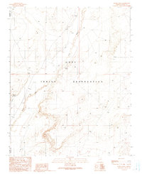
1991 Map of Burro Spring
USGS Topo · Published 1991About this map
Burro Spring serves as a central landmark in this high-desert landscape within the Hopi Indian Reservation. The 1991 provisional survey reveals a remote terrain defined by the winding course of Oraibi Wash, which is flanked by protective Levee structures and an Aqueduct system designed to manage scarce water resources. The presence of several Prospects and a Gravel Pit indicates small-scale mineral exploration and resource extraction in the late twentieth century. Located near the border of Coconino and Navajo Counties, the area is sparsely settled, with scattered infrastructure such as a Corral and various Water Tanks supporting the local pastoral economy. Distinctive natural features like the Falls and Shonto Spring provide rare points of perennial water in an otherwise arid environment.
Find a feature on this map
15 named features on this map. Tap any name to fly to it.
Don’t see what you’re looking for? This feature index may not catch every label — zoom into the map to look around manually.
Map Details
Editions of this 1991 Burro Spring Map
This is the sole edition of this map. No revisions or reprints were ever made.
Other maps of this area

1883 · Tusayan
USGS Topo · 1:250,000

1886 · Tusayan
USGS Topo · 1:250,000

1947 · Flagstaff
USGS Topo · 1:250,000

1954 · Flagstaff
USGS Topo · 1:250,000

1958 · Flagstaff
USGS Topo · 1:250,000

1960 · Flagstaff
USGS Topo · 1:250,000

1962 · Flagstaff
USGS Topo · 1:250,000

1966 · Oraibi
USGS Topo · 1:62,500

1966 · Tovar Mesa
USGS Topo · 1:62,500
1967 · Garces Mesas SE
USGS Topo · 1:24,000