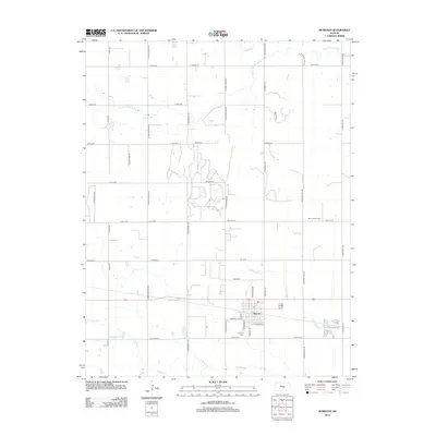
2012 Map of Burrton
USGS Topo · Published 2012About this map
The town of Burrton serves as the central hub of this Harvey County landscape, characterized by a structured grid of agricultural section lines and significant watercourses. The Little Arkansas River and Blaze Fork dominate the northern terrain, while the winding Kisiwa Cr and its tributary, N Br Kisiwa Cr, drain the southern plains. Local economic and community infrastructure is anchored by the Post Office in the heart of town and the Burrton Cem situated to the southwest. To the east, the Burrton Gas Field indicates the region's energy production history, integrated into a landscape of large-scale farming tracts. This 2012 survey illustrates how the settlement is bound by a precise road network, including regional arteries like N Sand Hill Rd and N Worthington Rd.
Find a feature on this map
46 named features on this map. Tap any name to fly to it.
Don’t see what you’re looking for? This feature index may not catch every label — zoom into the map to look around manually.
Map Details
Editions of this 2012 Burrton Map
This is the sole edition of this map. No revisions or reprints were ever made.
Other maps of this area

1889 · Cheney
USGS Topo · 1:125,000

1891 · Hutchinson
USGS Topo · 1:125,000

1891 · Cheney
USGS Topo · 1:125,000

1893 · Hutchinson
USGS Topo · 1:125,000

1901 · Cheney
USGS Topo · 1:125,000

1955 · Wichita
USGS Topo · 1:250,000

1955 · Hutchinson
USGS Topo · 1:250,000

1958 · Wichita
USGS Topo · 1:250,000

1958 · Patterson
USGS Topo · 1:24,000
1958 · Bentley
USGS Topo · 1:24,000