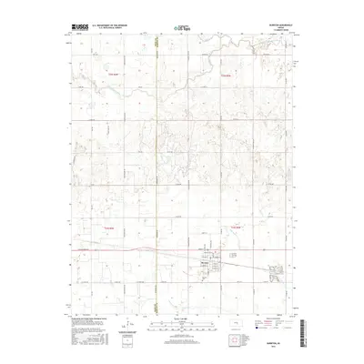
2015 Map of Burrton
USGS Topo · Published 2015About this map
Burrton serves as the central hub of this prairie landscape, where the agricultural grid meets the natural curves of the Little Arkansas River and Blaze Fork. The map documents a town structured around a clear street plan, including W Adams St, Washington St, and W Market St, reflecting its identity as a local commerce center. South of the main settlement lies the Burrton Cem, a key landmark for genealogical research. The surrounding terrain is defined by the winding paths of Kisiwa Cr and its northern branch, N Br Kisiwa Cr, which cut through the square sections of the Harvey and Reno county line. This survey captures the rural infrastructure of the mid-2010s, from established farm-to-market routes like Woodberry Rd and Co Rd 785 to the industrial and residential corridors that sustain this Kansas community.
Find a feature on this map
51 named features on this map. Tap any name to fly to it.
Don’t see what you’re looking for? This feature index may not catch every label — zoom into the map to look around manually.
Map Details
Editions of this 2015 Burrton Map
This is the sole edition of this map. No revisions or reprints were ever made.
Other maps of this area

1889 · Cheney
USGS Topo · 1:125,000

1891 · Hutchinson
USGS Topo · 1:125,000

1891 · Cheney
USGS Topo · 1:125,000

1893 · Hutchinson
USGS Topo · 1:125,000

1901 · Cheney
USGS Topo · 1:125,000

1955 · Wichita
USGS Topo · 1:250,000

1955 · Hutchinson
USGS Topo · 1:250,000

1958 · Wichita
USGS Topo · 1:250,000

1958 · Patterson
USGS Topo · 1:24,000
1958 · Bentley
USGS Topo · 1:24,000