1959 Map of Burrton
USGS Topo · Published 1960About this map
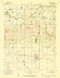
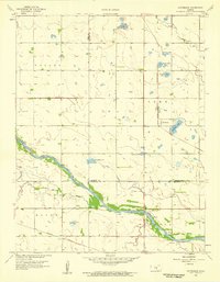
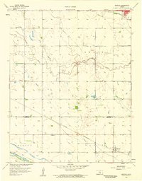
Burrton stands as a significant rail and industrial hub at the intersection of the Atchison Topeka and Santa Fe and St L S F railroads. This mid-century survey captures a landscape defined by its transition from agricultural prairie to energy extraction, evidenced by an Oil Refinery and numerous Oil wells scattered across the terrain. The presence of rural institutions like Lily Dale Sch, Willis Sch, and Fairview Sch provides a window into the distributed community structure of the late 1950s. The northern reaches of the quadrangle are dominated by the winding course of the Little Arkansas River and its tributaries, including Little Blaze Fork, which contrast with the straight-line geometry of the section roads and regional boundaries between Reno and Harvey counties.
Find a feature on this map
19 named features on this map. Tap any name to fly to it.
Don’t see what you’re looking for? This feature index may not catch every label — zoom into the map to look around manually.
Map Details
Editions of this 1959 Burrton Map
This is the sole edition of this map. No revisions or reprints were ever made.
Other maps of this area

1889 · Cheney
USGS Topo · 1:125,000

1891 · Hutchinson
USGS Topo · 1:125,000

1891 · Cheney
USGS Topo · 1:125,000

1893 · Hutchinson
USGS Topo · 1:125,000

1901 · Cheney
USGS Topo · 1:125,000

1955 · Wichita
USGS Topo · 1:250,000

1955 · Hutchinson
USGS Topo · 1:250,000

1958 · Wichita
USGS Topo · 1:250,000
1958 · Patterson
USGS Topo · 1:24,000
1958 · Bentley
USGS Topo · 1:24,000