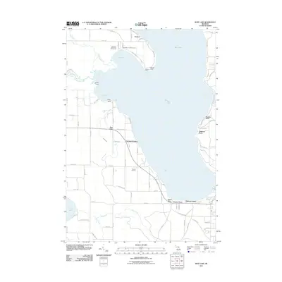
2011 Map of Burt Lake
USGS Topo · Published 2011About this map
Burt Lake dominates this northern Michigan landscape, where residential lakefront clusters like Waubun Beach, Chippewa Beach, and Kingsley Beach line the eastern shore. The western shoreline is defined by more irregular features, including Bullhead Bay, Snake Point, and the mouth of the Maple River. This 2011 survey highlights the region's historical and recreational significance through landmarks such as Saint Mary's Indian Cemetery near Maple Bay and the Ohioville Cemetery further south near Springwell Heights.
Find a feature on this map
86 named features on this map. Tap any name to fly to it.
Don’t see what you’re looking for? This feature index may not catch every label — zoom into the map to look around manually.
Map Details
Editions of this 2011 Burt Lake Map
This is the sole edition of this map. No revisions or reprints were ever made.
Other maps of this area

1955 · Cheboygan
USGS Topo · 1:250,000

1957 · Wolverine
USGS Topo · 1:62,500

1957 · Mullett Lake
USGS Topo · 1:62,500

1958 · Cheboygan
USGS Topo · 1:250,000

1958 · Pellston
USGS Topo · 1:62,500

1958 · Petoskey
USGS Topo · 1:62,500

1975 · Petoskey NE
USGS Topo · 1:24,000

1982 · Petoskey
USGS Topo · 1:100,000

1982 · Pellston
USGS Topo · 1:25,000
1982 · Indianville
USGS Topo · 1:25,000