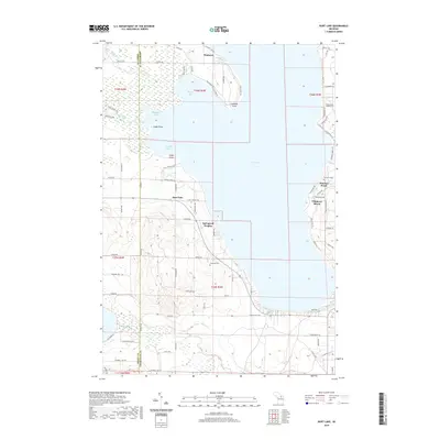
2019 Map of Burt Lake
USGS Topo · Published 2019About this map
The waters of Burt Lake dominate this northern Michigan landscape, where the confluence of the Maple River and the Crooked River enters through a complex of wetlands and inlets. The shoreline is punctuated by established resort-style developments and residential clusters such as Springwell Heights, Wauban Beach, and Chippewa Beach. The western shore is characterized by significant points like Colonial Point and Kings Point, while the interior sections are defined by a network of local roads such as Indian Rd and Brutus Rd. Genealogy and local history details are preserved in the naming of sites like Ohioville Cem and the Harmon Grave, providing specific points of reference for researchers tracing family ties to the Cheboygan and Emmet county lines.
Find a feature on this map
88 named features on this map. Tap any name to fly to it.
Don’t see what you’re looking for? This feature index may not catch every label — zoom into the map to look around manually.
Map Details
Editions of this 2019 Burt Lake Map
This is the sole edition of this map. No revisions or reprints were ever made.
Other maps of this area

1955 · Cheboygan
USGS Topo · 1:250,000

1957 · Wolverine
USGS Topo · 1:62,500

1957 · Mullett Lake
USGS Topo · 1:62,500

1958 · Cheboygan
USGS Topo · 1:250,000

1958 · Pellston
USGS Topo · 1:62,500

1958 · Petoskey
USGS Topo · 1:62,500

1975 · Petoskey NE
USGS Topo · 1:24,000

1982 · Petoskey
USGS Topo · 1:100,000

1982 · Pellston
USGS Topo · 1:25,000
1982 · Indianville
USGS Topo · 1:25,000