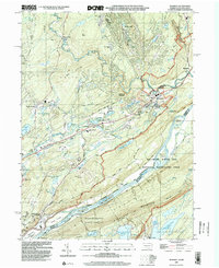
1999 Map of Bushkill
USGS Topo · Published 2002About this map
Kittatinny Mountain and the winding Delaware River dominate this late-twentieth-century landscape within the Delaware Water Gap National Recreation Area. The map illustrates a region defined by recreational development and local institutions, featuring numerous golf courses and the Shawnee Mtn Ski Area alongside established local landmarks like St Johns Ch, Wesley Ch, and the Middle Smithfield Sch. Small settlements such as Bushkill, Shoemakers, and Coolbaugh are situated along the valley floor, connected by roads like Keystone that skirt the base of Big Ridge and Kahkhout Mtn. To the south, the Worthington State Forest preserves more remote terrain, including Sunfish Pond and the high-altitude Upper Yards Creek Reservoir, while the Appalachian Trail follows the ridgeline overlooking Tocks Island and Poxono Island.
Find a feature on this map
66 named features on this map. Tap any name to fly to it.
Don’t see what you’re looking for? This feature index may not catch every label — zoom into the map to look around manually.
Map Details
Editions of this 1999 Bushkill Map
This is the sole edition of this map. No revisions or reprints were ever made.
Other maps of this area

1888 · Hackettstown
USGS Topo · 1:62,500

1891 · Wallpack
USGS Topo · 1:62,500

1891 · Delaware Water Gap
USGS Topo · 1:62,500

1893 · Delaware Water Gap
USGS Topo · 1:62,500

1893 · Wallpack
USGS Topo · 1:62,500

1894 · Hackettstown
USGS Topo · 1:62,500

1898 · Hackettstown
USGS Topo · 1:62,500

1900 · Raritan
USGS Topo · 1:125,000

1905 · Raritan
USGS Topo · 1:125,000

1905 · Hackettstown
USGS Topo · 1:62,500
Featured Places
- Blairstown, NJ
- Hardwick Township, NJ
- Lehman Township, PA
- Saw Creek, Lehman Township
- Middle Smithfield Township, PA