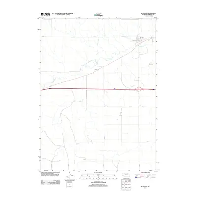
2011 Map of Bushnell
USGS Topo · Published 2011About this map
Lodgepole Creek meanders eastward through the high plains of western Nebraska, following a corridor shared by primary transportation routes in this 2011 survey. The village of Bushnell serves as the focal point for the region, anchored by the Bushnell Post Office and a network of rural roads that grid the surrounding agricultural land. To the southwest, the small settlement of Smeed sits along the rail line and highway, illustrating the historical reliance of these communities on the transit artery connecting them to larger regional centers. The map documents a landscape defined by irrigation and water management, evidenced by the James Dam Number 2 and a series of county roads like Co RD-17 and Co RD-13 that facilitate local movement between homesteads. Along the western edge, State Line Rd marks the political boundary, separating the open fields of Kimball County from its neighbors.
Find a feature on this map
16 named features on this map. Tap any name to fly to it.
Don’t see what you’re looking for? This feature index may not catch every label — zoom into the map to look around manually.
Map Details
Editions of this 2011 Bushnell Map
This is the sole edition of this map. No revisions or reprints were ever made.
Other maps of this area

1954 · Scottsbluff
USGS Topo · 1:250,000

1954 · Cheyenne
USGS Topo · 1:250,000

1958 · Cheyenne
USGS Topo · 1:250,000

1958 · Scottsbluff
USGS Topo · 1:250,000

1963 · Pine Bluffs
USGS Topo · 1:24,000

1963 · Lindbergh
USGS Topo · 1:24,000

1963 · Pine Bluffs SE
USGS Topo · 1:24,000

1968 · Pine Bluffs
USGS Topo · 1:24,000
1972 · Bushnell SW
USGS Topo · 1:24,000

1972 · Bushnell
USGS Topo · 1:24,000