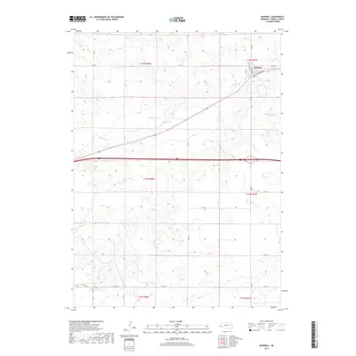
2017 Map of Bushnell
USGS Topo · Published 2017About this map
Bushnell stands as the primary settlement on this High Plains landscape, situated along the northern edge of the Interstate 80 corridor. The town's grid, defined by streets like Birch St and Maple St, reflects a traditional rail-oriented layout bordering Railroad Ave. The terrain is characterized by the winding path of Lodgepole Creek, which cuts through the center of the quadrangle, and the presence of Oliver Reservoir Number 2 to the east. This 2017 survey illustrates a modern rural infrastructure of county roads, such as Co Rd 17 and Co Rd 13, which overlay the section lines of the Public Land Survey System. Further south, State Line Road marks the approach to the Nebraska border, while the expansive topography suggests the dry-land farming and ranching heritage of Kimball County.
Find a feature on this map
24 named features on this map. Tap any name to fly to it.
Don’t see what you’re looking for? This feature index may not catch every label — zoom into the map to look around manually.
Map Details
Editions of this 2017 Bushnell Map
This is the sole edition of this map. No revisions or reprints were ever made.
Other maps of this area

1954 · Scottsbluff
USGS Topo · 1:250,000

1954 · Cheyenne
USGS Topo · 1:250,000

1958 · Cheyenne
USGS Topo · 1:250,000

1958 · Scottsbluff
USGS Topo · 1:250,000

1963 · Pine Bluffs
USGS Topo · 1:24,000

1963 · Lindbergh
USGS Topo · 1:24,000

1963 · Pine Bluffs SE
USGS Topo · 1:24,000

1968 · Pine Bluffs
USGS Topo · 1:24,000
1972 · Bushnell SW
USGS Topo · 1:24,000

1972 · Bushnell
USGS Topo · 1:24,000