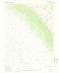
1981 Map of Bushnell Peak
USGS Topo · Published 1981About this map
Villa Grove sits as the primary settlement on this high-altitude landscape, where the San Luis Valley meets the northern Sangre de Cristo Mountains. The geography is defined by the continental divide transition between the Rio Grande National Forest and San Isabel National Forest. Local history is visible in the remnant Old Railroad Grade and the Villa Grove Cem, while the rugged eastern terrain is marked by high summits like Bushnell Peak and Mount Otto. Dozens of mining prospects are scattered across the drainage basins of Ferguson Creek and Miller Creek, signaling the area's prospecting legacy. The map also details early water infrastructure, including an Aqueduct crossing the valley floor and several springs that feed into the San Luis Creek system.
Find a feature on this map
44 named features on this map. Tap any name to fly to it.
Don’t see what you’re looking for? This feature index may not catch every label — zoom into the map to look around manually.
Map Details
Editions of this 1981 Bushnell Peak Map
2 editions found
Other maps of this area

1950 · Valley View Hot Springs
USGS Topo · 1:24,000

1954 · Pueblo
USGS Topo · 1:250,000

1956 · Montrose
USGS Topo · 1:250,000

1957 · Pueblo
USGS Topo · 1:250,000

1958 · Pueblo
USGS Topo · 1:250,000

1959 · Montrose
USGS Topo · 1:250,000

1959 · Bonanza
USGS Topo · 1:62,500

1959 · Howard
USGS Topo · 1:62,500

1960 · Montrose
USGS Topo · 1:250,000

1962 · Pueblo
USGS Topo · 1:250,000