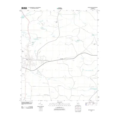
2011 Map of Butler East
USGS Topo · Published 2011About this map
The town of Butler serves as the focal point for this Taylor County landscape, situated at a junction of regional roads that connect the community to the surrounding agricultural and creek-bottom lands. The topography is defined by the extensive drainage systems of Horse Creek, Patsiliga Creek, and Beaver Creek, where numerous dams have created local impoundments such as Taylor Mill Lake, Minors Millpond, and Hortmans Pond. These water features, alongside smaller tributaries like Toteover Creek and Little Vine Creek, illustrate the historical reliance on local waterways for milling and recreation.
Find a feature on this map
56 named features on this map. Tap any name to fly to it.
Don’t see what you’re looking for? This feature index may not catch every label — zoom into the map to look around manually.
Map Details
Editions of this 2011 Butler East Map
This is the sole edition of this map. No revisions or reprints were ever made.
Other maps of this area

1955 · Phenix City
USGS Topo · 1:250,000

1957 · Phenix City
USGS Topo · 1:250,000

1958 · Phenix City
USGS Topo · 1:250,000

1971 · Rupert
USGS Topo · 1:24,000

1971 · Prattsburg
USGS Topo · 1:24,000

1971 · Fickling Mill
USGS Topo · 1:24,000

1971 · Reynolds
USGS Topo · 1:24,000
1971 · Roberta
USGS Topo · 1:24,000

1971 · Ideal North
USGS Topo · 1:24,000

1971 · Garden Valley
USGS Topo · 1:24,000