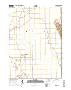
2017 Map of Butler Hill
USGS Topo · Published 2017About this map
Catlow Valley dominates this high desert portion of Harney County, illustrating a landscape defined by dramatic geological transitions and intermittent water patterns. The topography is sharply interrupted on the eastern edge by the Catlow Rim, where the land rises abruptly toward the summit of Butler Hill. This area, characteristic of the Oregon Outback, shows a sparse human footprint consisting primarily of long-distance routes like Catlow Valley Rd and Beckley Rd that follow the natural contours of the basin floor. At the southwestern corner, the drainage of the region terminates at the Rock Creek Sinks, a hydrologic feature where surface water disappears into the subterranean environment. The map captures a moment in the modern era where ranching access roads such as Rock Creek Ln and Blitzen Valley Rd provide the primary skeleton for navigating this isolated terrain.
Find a feature on this map
12 named features on this map. Tap any name to fly to it.
Don’t see what you’re looking for? This feature index may not catch every label — zoom into the map to look around manually.
Map Details
Editions of this 2017 Butler Hill Map
This is the sole edition of this map. No revisions or reprints were ever made.
Other maps of this area

1955 · Adel
USGS Topo · 1:250,000

1957 · Adel
USGS Topo · 1:250,000

1958 · Adel
USGS Topo · 1:250,000

1962 · Adel
USGS Topo · 1:250,000

1967 · Roaring Springs
USGS Topo · 1:24,000

1967 · Frenchglen
USGS Topo · 1:24,000

1971 · Duhaime Flat East
USGS Topo · 1:24,000

1971 · Blitzen
USGS Topo · 1:24,000

1971 · Butler Hill
USGS Topo · 1:24,000
1971 · Blitzen SW
USGS Topo · 1:24,000