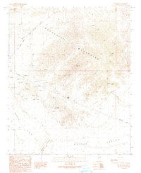
1990 Map of Butler Pass
USGS Topo · Published 1990About this map
The Buckskin Mountains dominate this arid landscape in La Paz County, where a legacy of resource extraction is evident through numerous prospect sites and an occasional Mine Shaft. A striking geographic transition occurs as the highlands descend toward the Cactus Plain to the southwest and the Butler Valley to the southeast. Transportation through this desert terrain is defined by the Lincoln Ranch Road and several 4wd tracks, which navigate the gaps between the mountains and the Bouse Hills. Of particular interest to industrial historians is the Old Railroad Grade running through the northwestern sector, a physical reminder of past logistics in this part of Arizona. The prominent Battleship Peak serves as a central landmark overlooking Butler Pass, marking a key transit point between the rugged northern ridges and the broad valley floors below.
Find a feature on this map
17 named features on this map. Tap any name to fly to it.
Don’t see what you’re looking for? This feature index may not catch every label — zoom into the map to look around manually.
Map Details
Editions of this 1990 Butler Pass Map
This is the sole edition of this map. No revisions or reprints were ever made.
Other maps of this area

1923 · Signal
USGS Topo · 1:250,000

1942 · Signal
USGS Topo · 1:250,000

1942 · Vicksburg
USGS Topo · 1:250,000

1950 · Prescott
USGS Topo · 1:250,000

1954 · Prescott
USGS Topo · 1:250,000

1954 · Phoenix
USGS Topo · 1:250,000

1957 · Phoenix
USGS Topo · 1:250,000

1958 · Prescott
USGS Topo · 1:250,000

1958 · Phoenix
USGS Topo · 1:250,000

1959 · Prescott
USGS Topo · 1:250,000