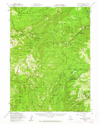
1958 Map of Butte Meadows
USGS Topo · Published 1963About this map
Butte Meadows serves as a central point in this 1950s survey, illustrating a landscape of high-elevation mountain settlements and timber management. The map documents a transition in local infrastructure, showing the Skyway and Humboldt Road providing access to remote locations like Savercool Place and Lomo. The presence of several established camps, including Camp Lassen, Hawkins Camp, and West Branch Camp, suggests a region defined by seasonal occupation and forest service operations. Water resources are prominent, with the drainage of Mill Creek and Big Chico Creek carving through the terrain. Notable local landmarks like the Cemetery near Butte Meadows and the Chaparral Guard Sta offer specific points of interest for genealogists and researchers tracing the development of the Lassen National Forest during the mid-twentieth century.
Find a feature on this map
93 named features on this map. Tap any name to fly to it.
Don’t see what you’re looking for? This feature index may not catch every label — zoom into the map to look around manually.
Map Details
Editions of this 1958 Butte Meadows Map
3 editions found
Other maps of this area

1886 · Lassen Peak
USGS Topo · 1:250,000

1888 · Bidwell Bar
USGS Topo · 1:125,000

1891 · Bidwell Bar
USGS Topo · 1:125,000

1891 · Chico
USGS Topo · 1:125,000

1892 · Lassen Peak
USGS Topo · 1:250,000

1893 · Chico
USGS Topo · 1:125,000

1893 · Bidwell Bar
USGS Topo · 1:125,000

1894 · Lassen Peak
USGS Topo · 1:250,000

1895 · Bidwell Bar
USGS Topo · 1:125,000

1895 · Chico
USGS Topo · 1:125,000