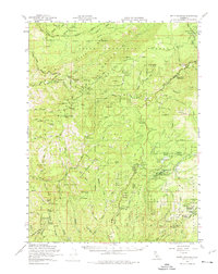
1958 Map of Butte Meadows
USGS Topo · Published 1974About this map
Butte Meadows serves as a central point of reference in this mid-century survey of the high country spanning the Tehama and Butte County line. The map captures a landscape defined by forest management and seasonal mountain work, featuring a dense network of forest roads like Ponderosa Way and Humbug Rd. Small settlements and named camps such as Campbellville, Savercool Place, and Hawkins Camp suggest the legacy of early ranching and logging in the Lassen National Forest. Evidence of fire lookout infrastructure is prominent at Windy Cut Lookout and Colby Mtn Lookout. The terrain is marked by dramatic watercourses including Deer Creek and Big Chico Creek, alongside curiously named landmarks like Devils Parade Ground and the Devils Kitchen. This survey preserves the locations of vital water sources for mountain travel, including Bennett Spring and Soda Springs.
Find a feature on this map
105 named features on this map. Tap any name to fly to it.
Don’t see what you’re looking for? This feature index may not catch every label — zoom into the map to look around manually.
Map Details
Editions of this 1958 Butte Meadows Map
3 editions found
Other maps of this area

1886 · Lassen Peak
USGS Topo · 1:250,000

1888 · Bidwell Bar
USGS Topo · 1:125,000

1891 · Bidwell Bar
USGS Topo · 1:125,000

1891 · Chico
USGS Topo · 1:125,000

1892 · Lassen Peak
USGS Topo · 1:250,000

1893 · Chico
USGS Topo · 1:125,000

1893 · Bidwell Bar
USGS Topo · 1:125,000

1894 · Lassen Peak
USGS Topo · 1:250,000

1895 · Bidwell Bar
USGS Topo · 1:125,000

1895 · Chico
USGS Topo · 1:125,000