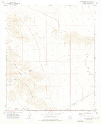
1973 Map of Butterfield Pass
USGS Topo · Published 1976About this map
Butterfield Stage Route corridors trace the historic passage through the Maricopa Mountains, following the same natural gaps used by mid-19th-century mail carriers. The terrain centers on Butterfield Pass, a critical waypoint for travelers navigating the arid landscape between water sources like Conley Tank and Fortymile Desert Tank. Evidence of early overland travel is preserved through labels for the Desert Station (Site) and the Butterfield Trail Campsite, providing specific locations for historians and archaeologists studying the Gila Trail's legacy.
Find a feature on this map
11 named features on this map. Tap any name to fly to it.
Don’t see what you’re looking for? This feature index may not catch every label — zoom into the map to look around manually.
Map Details
Editions of this 1973 Butterfield Pass Map
2 editions found
Other maps of this area

1951 · Estrella
USGS Topo · 1:62,500

1951 · Gila Bend
USGS Topo · 1:62,500

1951 · Mobile
USGS Topo · 1:62,500

1951 · Cotton Center
USGS Topo · 1:62,500

1953 · Ajo
USGS Topo · 1:250,000

1954 · Phoenix
USGS Topo · 1:250,000

1957 · Ajo
USGS Topo · 1:250,000

1957 · Phoenix
USGS Topo · 1:250,000

1958 · Ajo
USGS Topo · 1:250,000

1958 · Phoenix
USGS Topo · 1:250,000