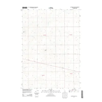
2013 Map of Butterfly Butte
USGS Topo · Published 2013About this map
Butterfly Butte and Kettle Butte dominate the landscape of this high desert region in eastern Idaho. The topography is defined by the volcanic formations typical of the Snake River Plain, where these prominent elevations rise above a systematic grid of section lines and secondary roads. The irrigation and drainage patterns are evidenced by the Kettle Butte Drain, which cuts through the northern sections of the township, while the W Arco Hwy provides the primary east-west transportation artery across the southern portion of the quadrangle.
Find a feature on this map
12 named features on this map. Tap any name to fly to it.
Don’t see what you’re looking for? This feature index may not catch every label — zoom into the map to look around manually.
Map Details
Editions of this 2013 Butterfly Butte Map
This is the sole edition of this map. No revisions or reprints were ever made.
Other maps of this area

1948 · Woodville
USGS Topo · 1:24,000

1949 · Roberts
USGS Topo · 1:62,500

1949 · Roberts
USGS Topo · 1:24,000

1949 · Shattuck Butte
USGS Topo · 1:24,000

1950 · Shattuck Butte
USGS Topo · 1:24,000

1950 · Woodville
USGS Topo · 1:24,000

1950 · Roberts
USGS Topo · 1:24,000

1955 · Idaho Falls
USGS Topo · 1:250,000

1958 · Idaho Falls
USGS Topo · 1:250,000
1959 · Woodville
USGS Topo · 1:24,000