1950 Map of Roberts
USGS Topo · Published 1950About this map
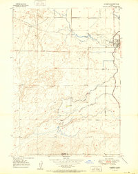
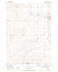
Roberts serves as the focal point for this 1950 survey, situated where the Union Pacific railroad tracks and Route 91 parallel the eastern edge of the Snake River plain. The landscape is defined by an intricate network of irrigation infrastructure essential to the high desert agriculture of the region. Systems such as the Poitevin Ditch, Mc Carthy Ditch, and Larsen Ditch weave through the terrain, managing water flow from Taylor Slough toward Market Lake. The topography shifts from the level irrigation basins near the settlement to the more varied elevations of the Butte to the south. This mapping captures the vital intersection of rail transport and hydraulic engineering that sustained small Idaho communities in the mid-twentieth century, showing the precise placement of pumps and canals that transformed the arid Bonneville and Jefferson county line area.
Find a feature on this map
17 named features on this map. Tap any name to fly to it.
Don’t see what you’re looking for? This feature index may not catch every label — zoom into the map to look around manually.
Map Details
Editions of this 1950 Roberts Map
This is the sole edition of this map. No revisions or reprints were ever made.
Other maps of this area
1948 · Lewisville
USGS Topo · 1:24,000
1948 · Idaho Falls North
USGS Topo · 1:24,000

1949 · Idaho Falls North
USGS Topo · 1:24,000
1949 · Lewisville
USGS Topo · 1:24,000

1949 · Roberts
USGS Topo · 1:62,500
1949 · Roberts
USGS Topo · 1:24,000
1949 · Shattuck Butte
USGS Topo · 1:24,000

1950 · Shattuck Butte
USGS Topo · 1:24,000

1955 · Idaho Falls
USGS Topo · 1:250,000

1958 · Idaho Falls
USGS Topo · 1:250,000