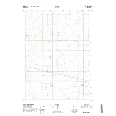
2020 Map of Butterfly Butte
USGS Topo · Published 2020About this map
Butterfly Butte and Kettle Butte dominate this section of the Bonneville County landscape, serving as the primary topographic landmarks in an area defined by agricultural development and water management. The irrigation network is represented by the Kettle Butte Drain, which snakes across the northern and central sections of the survey. This 2020 edition documents the precise section lines and modern road grid, including 155th Rd W and 81st Rd N, illustrating how the land has been partitioned for use. The map provides a clear record of rural infrastructure, tracing the rectilinear paths of W 113 N and N 135 W as they navigate around the distinct volcanic rises and drainage channels of this eastern Idaho region.
Find a feature on this map
14 named features on this map. Tap any name to fly to it.
Don’t see what you’re looking for? This feature index may not catch every label — zoom into the map to look around manually.
Map Details
Editions of this 2020 Butterfly Butte Map
This is the sole edition of this map. No revisions or reprints were ever made.
Other maps of this area

1948 · Woodville
USGS Topo · 1:24,000

1949 · Roberts
USGS Topo · 1:62,500

1949 · Roberts
USGS Topo · 1:24,000

1949 · Shattuck Butte
USGS Topo · 1:24,000

1950 · Shattuck Butte
USGS Topo · 1:24,000

1950 · Woodville
USGS Topo · 1:24,000

1950 · Roberts
USGS Topo · 1:24,000

1955 · Idaho Falls
USGS Topo · 1:250,000

1958 · Idaho Falls
USGS Topo · 1:250,000
1959 · Woodville
USGS Topo · 1:24,000