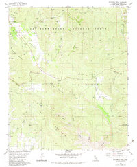
1981 Map of Butterfly Peak
USGS Topo · Published 1982About this map
Butterfly Peak and Thomas Mountain dominate this landscape within the San Bernardino National Forest, where the terrain transitions from the high peaks down toward the Santa Rosa Indian Reservation. Mining history is preserved through labels for the New Hemet Bell Mine and Gold Shot Mine near Gold Hill, while the presence of Kenworthy Station and various springs like Watering Trough Spring indicate the essential water management required in this environment. The map details a network of canyons, including Palm Canyon and Horse Canyon, which cut through Table Mountain. Historic land use is evident in the inclusion of a Cem and a Lookout station, marking points of human presence in the high country. These features together show a region defined by both its natural elevation and the early 20th-century industries that attempted to extract wealth from its slopes.
Find a feature on this map
55 named features on this map. Tap any name to fly to it.
Don’t see what you’re looking for? This feature index may not catch every label — zoom into the map to look around manually.
Map Details
Editions of this 1981 Butterfly Peak Map
4 editions found
Other maps of this area

1901 · Southern California Sheet No. 1
USGS Topo · 1:250,000

1901 · San Jacinto
USGS Topo · 1:125,000

1903 · Ramona
USGS Topo · 1:125,000

1904 · Indio
USGS Topo · 1:125,000

1904 · Southern California Sheet No. 2
USGS Topo · 1:250,000

1904 · Southern California Sheet No. 1
USGS Topo · 1:250,000

1931 · Vallecito
USGS Topo · 1:125,000

1939 · Warner Springs
USGS Topo · 1:62,500

1940 · Hemet Reservoir
USGS Topo · 1:62,500

1941 · Toro Peak
USGS Topo · 1:62,500