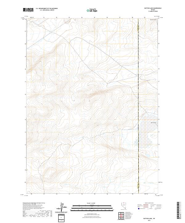
2021 Map of Button Lake
USGS Topo · Published 2021About this map
The Owyhee Desert characterizes this high plateau region along the border of Humboldt and Elko counties. This arid landscape is defined by its subtle drainage patterns and seasonal water features, most notably the wide, marshy expanse of Button Lake in the eastern portion of the quadrangle. The hydrology of the area is primarily shaped by intermittent flows, including Lake Cr which traverses the southern section. The map reveals the stark, geometric precision of the Public Land Survey System, with township lines such as t45n r43e and t44n r44e cutting across the undulating terrain. This 2021 survey documents the remote character of the Nevada backcountry, where traditional desert basin features remain largely undisturbed by modern development or infrastructure.
Find a feature on this map
10 named features on this map. Tap any name to fly to it.
Don’t see what you’re looking for? This feature index may not catch every label — zoom into the map to look around manually.
Map Details
Editions of this 2021 Button Lake Map
This is the sole edition of this map. No revisions or reprints were ever made.
Other maps of this area

1882 · Paradise
USGS Topo · 1:250,000

1893 · Paradise
USGS Topo · 1:250,000

1955 · McDermitt
USGS Topo · 1:250,000

1959 · McDermitt
USGS Topo · 1:250,000

1973 · Star Valley Ridge SW
USGS Topo · 1:24,000

1973 · Button Lake Well
USGS Topo · 1:24,000

1973 · Humboldt Hill
USGS Topo · 1:24,000
1980 · Button Lake
USGS Topo · 1:24,000

1980 · Greeley Flat
USGS Topo · 1:24,000
1980 · Maiden Butte
USGS Topo · 1:24,000