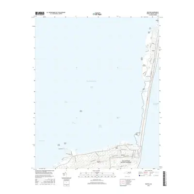
2016 Map of Buxton
USGS Topo · Published 2016About this map
Hatteras Island and the Outer Banks define this coastal landscape, where the fragile barrier between the Atlantic Ocean and Pamlico Sound is mapped in detail. The settlements of Avon and Buxton anchor the northern and southern portions of the habitable land, connected by the long corridor of One Way Rd. Much of the territory falls within the Cape Hatteras National Seashore, preserving marshy reaches like Jennette Sedge and the waters of Canadian Hole. Historical land use is visible in the network of residential streets and access points, such as Flowers Ridge Rd and Buxton Back Rd. The map also captures the complex maritime geography of the sound side, including Devil Shoals, Kings Island, and Brigand Bay, illustrating how the shifting sands and shallow channels of the North Carolina coast dictate the footprint of human habitation.
Find a feature on this map
54 named features on this map. Tap any name to fly to it.
Don’t see what you’re looking for? This feature index may not catch every label — zoom into the map to look around manually.
Map Details
Editions of this 2016 Buxton Map
This is the sole edition of this map. No revisions or reprints were ever made.
Other maps of this area

1948 · Cape Hatteras
USGS Topo · 1:24,000

1948 · Buxton
USGS Topo · 1:24,000

1950 · Cape Hatteras
USGS Topo · 1:24,000

1950 · Buxton
USGS Topo · 1:24,000

1955 · Wanchese
USGS Topo · 1:250,000

1957 · Manteo
USGS Topo · 1:250,000

1960 · Manteo
USGS Topo · 1:250,000

1985 · Cape Hatteras
USGS Topo · 1:100,000

2002 · Cape Hatteras
USGS Topo · 1:24,000

2011 · Buxton
USGS Topo · 1:24,000