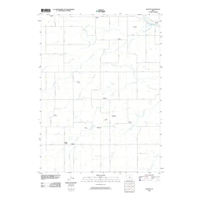
2010 Map of Buxton
USGS Topo · Published 2010About this map
Buxton and Cricket serve as focal points in this section of rural Iowa, where a dense network of country roads like Dover Ave and Barrows Ave connects long-established farming communities. The landscape is deeply carved by the drainage systems of Bluff Creek and Turkey Run, which flow generally southeast toward the Des Moines River in the northeastern corner. This water-rich environment is punctuated by a high density of burial grounds, including the Buxton Cemetery, Pringle Cemetery, and Smith Cemetery, suggesting a well-settled history of family farms and early township development. At the northern edge, the Eveland Bridge provides a critical crossing over the Des Moines River near the small settlement of Eveland, while smaller waterways like North Coal Creek and Little Bluff Creek further define the local topography.
Find a feature on this map
53 named features on this map. Tap any name to fly to it.
Don’t see what you’re looking for? This feature index may not catch every label — zoom into the map to look around manually.
Map Details
Editions of this 2010 Buxton Map
This is the sole edition of this map. No revisions or reprints were ever made.
Other maps of this area

1910 · Pella
USGS Topo · 1:62,500

1912 · Pella
USGS Topo · 1:62,500

1929 · Albia
USGS Topo · 1:62,500

1954 · Des Moines
USGS Topo · 1:250,000

1956 · Des Moines
USGS Topo · 1:250,000

1957 · Des Moines
USGS Topo · 1:250,000

1968 · Oskaloosa
USGS Topo · 1:24,000

1968 · Eddyville
USGS Topo · 1:24,000
1968 · Avery
USGS Topo · 1:24,000

1969 · Des Moines
USGS Topo · 1:250,000