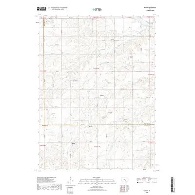
2018 Map of Buxton
USGS Topo · Published 2018About this map
Buxton and Miami anchor this portion of the Iowa landscape where the borders of Mahaska, Marion, and Monroe counties meet. The terrain is deeply carved by the Des Moines River and its numerous tributaries, including Coal Creek and Bluff Cr. This area is particularly rich for genealogical research, documenting a high density of small burial grounds such as Weldon Cem, Pringle Cem, and Boles Cem. The map illustrates the rural infrastructure of the early 21st century, centered on crossings like Eveland Bridge and river access points like Courtney's Landing. Smaller settlements like Cricket and Eveland appear as established nodes within a network of county highways and local roads that follow the undulating ridges between the river valleys.
Find a feature on this map
32 named features on this map. Tap any name to fly to it.
Don’t see what you’re looking for? This feature index may not catch every label — zoom into the map to look around manually.
Map Details
Editions of this 2018 Buxton Map
This is the sole edition of this map. No revisions or reprints were ever made.
Other maps of this area

1910 · Pella
USGS Topo · 1:62,500

1912 · Pella
USGS Topo · 1:62,500

1929 · Albia
USGS Topo · 1:62,500

1954 · Des Moines
USGS Topo · 1:250,000

1956 · Des Moines
USGS Topo · 1:250,000

1957 · Des Moines
USGS Topo · 1:250,000

1968 · Oskaloosa
USGS Topo · 1:24,000

1968 · Eddyville
USGS Topo · 1:24,000
1968 · Avery
USGS Topo · 1:24,000

1969 · Des Moines
USGS Topo · 1:250,000