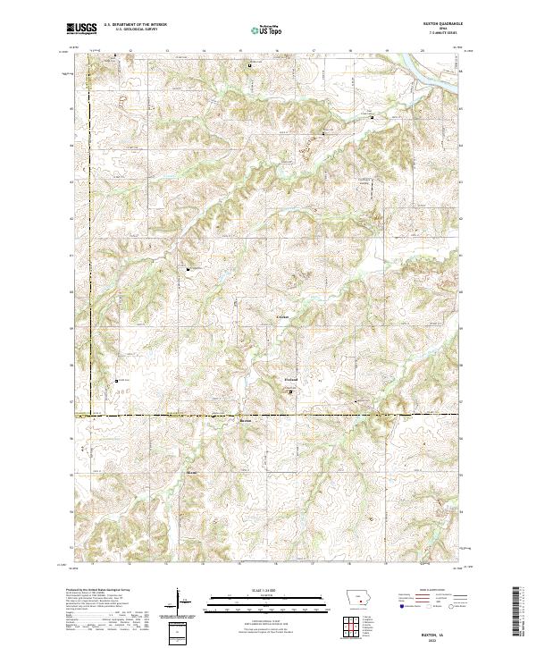
2022 Map of Buxton
USGS Topo · Published 2022About this map
Buxton and the neighboring settlement of Miami sit at the intersection of Mahaska and Monroe counties, an area characterized by the dissected uplands above the Des Moines River. This landscape is heavily marked by its local history, containing numerous burial grounds such as Buxton Cem, Pringle Cem, and Coal Creek Cem. The terrain is carved by a dense network of drainages including Turkey Run, Coal Creek, and Bluff Cr, which flow toward the primary river valley. Courtney's Landing serves as a notable landmark along the river's edge in the northeast. The presence of smaller communities like Eveland and Cricket connected by a grid of county roads and named avenues, such as Cordova Ave and Elba Ave, illustrates the persistent rural settlement pattern of south-central Iowa.
Find a feature on this map
74 named features on this map. Tap any name to fly to it.
Don’t see what you’re looking for? This feature index may not catch every label — zoom into the map to look around manually.
Map Details
Editions of this 2022 Buxton Map
This is the sole edition of this map. No revisions or reprints were ever made.
Other maps of this area

1910 · Pella
USGS Topo · 1:62,500

1912 · Pella
USGS Topo · 1:62,500

1929 · Albia
USGS Topo · 1:62,500

1954 · Des Moines
USGS Topo · 1:250,000

1956 · Des Moines
USGS Topo · 1:250,000

1957 · Des Moines
USGS Topo · 1:250,000

1968 · Oskaloosa
USGS Topo · 1:24,000

1968 · Eddyville
USGS Topo · 1:24,000
1968 · Avery
USGS Topo · 1:24,000

1969 · Des Moines
USGS Topo · 1:250,000