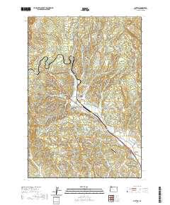
2020 Map of Buxton
USGS Topo · Published 2020About this map
Buxton and Manning anchor this corner of the Tualatin Valley, situated along the corridor of the Banks-Vernonia State Trail. The landscape transitions from the valley floor near Davies Junction into the steep rises of Wildcat Mtn and Green Mtn. This modern survey documents the rural character of northern Washington County, where agricultural operations like Park Farms Cr coexist with water management at the Schmadeke Reservoir and Green Valley Reservoir.
Find a feature on this map
89 named features on this map. Tap any name to fly to it.
Don’t see what you’re looking for? This feature index may not catch every label — zoom into the map to look around manually.
Map Details
Editions of this 2020 Buxton Map
This is the sole edition of this map. No revisions or reprints were ever made.
Other maps of this area

1940 · Vernonia
USGS Topo · 1:62,500

1941 · Keasey
USGS Topo · 1:62,500

1941 · Timber
USGS Topo · 1:62,500

1941 · Gales Creek
USGS Topo · 1:62,500

1943 · Vernonia
USGS Topo · 1:62,500

1943 · Keasey
USGS Topo · 1:62,500

1948 · Vancouver
USGS Topo · 1:250,000

1950 · Vancouver
USGS Topo · 1:250,000

1950 · Vancouver
USGS Topo · 1:250,000

1955 · Timber
USGS Topo · 1:62,500