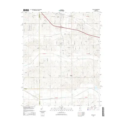
2015 Map of Byhalia
USGS Topo · Published 2015About this map
Byhalia serves as the primary hub in this northern Mississippi survey, which documents the convergence of Marshall, DeSoto, and Tate counties. The landscape is defined by its numerous family and community burial grounds, including Watkins Cem, Macedonia Cem, and Harmonia Cem, suggesting deep genealogical roots throughout the region. Smaller communities like Warsaw, Watson, and Coal Oil Corner are connected by a network of rural roads such as Myers Plantation Rd and Red Hills Rd. To the south, the terrain becomes more hydrological with the Red Banks Creek Canal and Pigeon Roost Creek flowing across the quadrangle. This 2015 update provides a modern record of land divisions and the persisting presence of historic cemeteries alongside newer infrastructure like Church Station Pkwy.
Find a feature on this map
116 named features on this map. Tap any name to fly to it.
Don’t see what you’re looking for? This feature index may not catch every label — zoom into the map to look around manually.
Map Details
Editions of this 2015 Byhalia Map
This is the sole edition of this map. No revisions or reprints were ever made.
Other maps of this area

1944 · Senatobia
USGS Topo · 1:62,500

1944 · Hernando
USGS Topo · 1:62,500

1944 · Tyro
USGS Topo · 1:62,500

1948 · Byhalia
USGS Topo · 1:62,500

1956 · Tupelo
USGS Topo · 1:250,000

1958 · Tupelo
USGS Topo · 1:250,000
1971 · Byhalia
USGS Topo · 1:24,000
1971 · Marianna
USGS Topo · 1:24,000

1971 · Wyatte
USGS Topo · 1:24,000
1971 · Red Banks
USGS Topo · 1:24,000