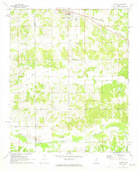
1971 Map of Byhalia
USGS Topo · Published 1973About this map
Byhalia serves as the primary hub of this north Mississippi landscape, where the St Louis - San Francisco railroad cuts a diagonal line through the Marshall County countryside. The map reveals a deeply established rural community defined by its network of country churches and family burial grounds. Notable sites like St Pauls Ch and its associated St Pauls Cem are joined by smaller settlements such as Watson and Coal Oil Corner. The terrain is drained by a complex system of waterways, including Pigeon Roost Creek and Red Banks Creek. The presence of a Gaging Station and a Sewage Disposal Pond indicate the infrastructure supporting the area's growth in the early 1970s. For genealogists, the density of named cemeteries like Isaac Cem and Ingram Cem provides essential location data for tracing local family roots.
Find a feature on this map
28 named features on this map. Tap any name to fly to it.
Don’t see what you’re looking for? This feature index may not catch every label — zoom into the map to look around manually.
Map Details
Editions of this 1971 Byhalia Map
This is the sole edition of this map. No revisions or reprints were ever made.
Other maps of this area

1944 · Senatobia
USGS Topo · 1:62,500

1944 · Hernando
USGS Topo · 1:62,500

1944 · Tyro
USGS Topo · 1:62,500

1948 · Byhalia
USGS Topo · 1:62,500

1956 · Tupelo
USGS Topo · 1:250,000

1958 · Tupelo
USGS Topo · 1:250,000
1971 · Marianna
USGS Topo · 1:24,000

1971 · Wyatte
USGS Topo · 1:24,000
1971 · Red Banks
USGS Topo · 1:24,000
1971 · Mt. Pleasant
USGS Topo · 1:24,000