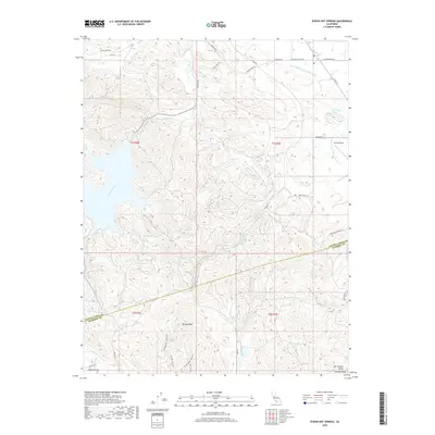
2018 Map of Byron Hot Springs
USGS Topo · Published 2018About this map
Byron Hot Springs sits at the foot of the Diablo Range, where the foothills meet the level expanse of the San Joaquin Valley. This landscape is defined by the critical infrastructure of California water management, featuring the Byron-Bethany Irrigation Canal and the S Bay Aqueduct cutting across the terrain. While the northeastern corner shows the transition to the Central Valley floor near the Byron Airport, the southwestern portion is dominated by the heights of Brushy Peak. A network of recreational paths, including the Brushy Peak Loop Trail, Tamcan Trail, and W Side Loop Trail, provides access to the higher elevations. Drainage for the region is handled by Kellogg Creek and Marsh Creek, which flow toward the valley floor, illustrating the complex relationship between natural hydrology and industrial-scale irrigation in this region.
Find a feature on this map
34 named features on this map. Tap any name to fly to it.
Don’t see what you’re looking for? This feature index may not catch every label — zoom into the map to look around manually.
Map Details
Editions of this 2018 Byron Hot Springs Map
This is the sole edition of this map. No revisions or reprints were ever made.
Other maps of this area

1896 · Mt. Diablo
USGS Topo · 1:62,500

1898 · Mt. Diablo
USGS Topo · 1:62,500

1906 · Pleasanton
USGS Topo · 1:62,500

1907 · Tesla
USGS Topo · 1:62,500

1911 · Byron Hot Springs
USGS Topo · 1:31,680

1913 · Woodward Island
USGS Topo · 1:31,680

1914 · Brentwood
USGS Topo · 1:31,680

1914 · Bethany
USGS Topo · 1:31,680

1916 · Lone Tree Valley
USGS Topo · 1:31,680

1916 · Byron Hot Springs
USGS Topo · 1:31,680