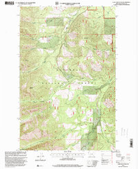
1997 Map of Cable Mountain
USGS Topo · Published 2000About this map
Old Town (Site) sits along the banks of Libby Creek in this late 20th-century revision of the mountain landscape south of Libby. The terrain is defined by the high peaks of the Kootenai National Forest, including Big Hoodoo Mountain and the namesake Cable Mountain. A complex network of drainage basins, such as Big Cherry Creek and Snowshoe Creek, carves through the timbered slopes. Evidence of the region's mineral history is present in several areas, notably a Prospect located near Leigh Creek, reflecting the prospecting era that preceded the establishment of the Cabinet Mountains Wilderness. The southern portion of the map traces the Poorman Creek and Ramsey Creek corridors, while the Libby Guide Meridian serves as a critical surveying anchor for the public land survey system in this part of Lincoln County.
Find a feature on this map
25 named features on this map. Tap any name to fly to it.
Don’t see what you’re looking for? This feature index may not catch every label — zoom into the map to look around manually.
Map Details
Editions of this 1997 Cable Mountain Map
This is the sole edition of this map. No revisions or reprints were ever made.
Other maps of this area

1920 · Libby
USGS Topo · 1:125,000

1920 · Jennings
USGS Topo · 1:125,000

1930 · Libby
USGS Topo · 1:125,000

1932 · Libby
USGS Topo · 1:125,000

1935 · Thompson Lakes
USGS Topo · 1:96,000

1942 · Thompson Lakes
USGS Topo · 1:125,000

1957 · Kalispell
USGS Topo · 1:250,000

1960 · Kalispell
USGS Topo · 1:250,000

1961 · Kalispell
USGS Topo · 1:250,000

1963 · Swede Mountain
USGS Topo · 1:24,000