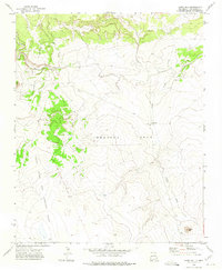
1972 Map of Cabra Hill
USGS Topo · Published 1975About this map
The Preston Beck Grant and the Anton Chico and Preston Beck Grant Boundary dominate the landscape of San Miguel County in the early 1970s. This land division reflects the complex history of Spanish and Mexican land grants in the region, where large parcels of territory were managed as cohesive units. The Conchas River cuts through the northern portion of the map, fed by tributaries like Salitre Creek and Cabra Creek.
Find a feature on this map
11 named features on this map. Tap any name to fly to it.
Don’t see what you’re looking for? This feature index may not catch every label — zoom into the map to look around manually.
Map Details
Editions of this 1972 Cabra Hill Map
This is the sole edition of this map. No revisions or reprints were ever made.
Other maps of this area

1892 · Corazon
USGS Topo · 1:125,000

1894 · Corazon
USGS Topo · 1:125,000

1954 · Santa Fe
USGS Topo · 1:250,000

1958 · Santa Fe
USGS Topo · 1:250,000

1963 · Cactus Tank
USGS Topo · 1:24,000

1963 · Mesa Cherisco
USGS Topo · 1:24,000
1963 · Horse Pasture Tank
USGS Topo · 1:24,000
1963 · Bar Y Ranch
USGS Topo · 1:24,000

1963 · Flagstone Mountain
USGS Topo · 1:24,000
1972 · Mesa Pino
USGS Topo · 1:24,000