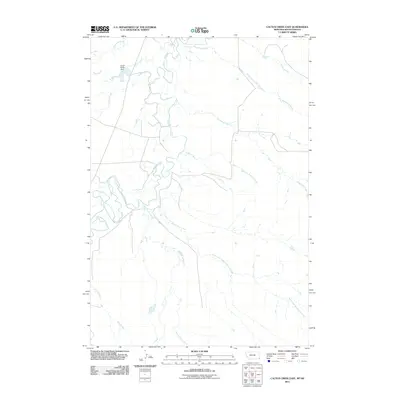
2011 Map of Cactus Creek East
USGS Topo · Published 2011About this map
The Little Missouri River carves a meandering path through this high plains region on the Montana-South Dakota border, defining a landscape shaped by its complex drainage network. The river's winding oxbows are fed by numerous seasonal tributaries, including Cactus Creek, Enerson Creek, and Bickerdyke Creek. A singular piece of infrastructure, the Snow White Dam, stands near the junction of Mud Creek and Cactus Creek, illustrating local efforts to manage water resources in this arid environment. The southern portion of the quadrangle is dominated by the intricate branching of Beaver Dam Creek and the North Fork Beaver Dam Creek, where the terrain transitions into the more dissected uplands of Carter County. This survey captures a moment when the natural hydrologic patterns of the river valley remained the primary organizing force of the land, with few roads interrupting the drainage basins of Plum Creek and Roburge Creek.
Find a feature on this map
12 named features on this map. Tap any name to fly to it.
Don’t see what you’re looking for? This feature index may not catch every label — zoom into the map to look around manually.
Map Details
Editions of this 2011 Cactus Creek East Map
This is the sole edition of this map. No revisions or reprints were ever made.
Other maps of this area

1935 · Harding
USGS Topo · 1:125,000

1954 · Lemmon
USGS Topo · 1:250,000

1954 · Ekalaka
USGS Topo · 1:250,000

1956 · Ekalaka
USGS Topo · 1:250,000

1957 · Lemmon
USGS Topo · 1:250,000

1958 · Ekalaka
USGS Topo · 1:250,000

1965 · Ekalaka
USGS Topo · 1:250,000
1978 · J K Butte
USGS Topo · 1:24,000
1978 · Indian Butte
USGS Topo · 1:24,000
1978 · Gustave
USGS Topo · 1:24,000