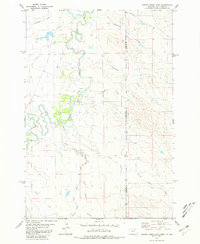
1980 Map of Cactus Creek East
USGS Topo · Published 1981About this map
The Little Missouri River meanders through this remote borderland during the early 1970s, carving a complex network of oxbows and channels across the landscape. This survey documents a quiet rangeland where the Black Hills Meridian defines the boundary between Montana and South Dakota, as well as the line between Carter County and Harding County. The terrain is defined by a dense web of seasonal drainage, including Cottonwood Creek, Bickerdyke Creek, and the headwaters of Beaver Dam Creek. Evidence of local resource extraction is limited to a single Gravel Pit near the river, while several Ford crossings indicate the historic routes used to navigate the river before modern infrastructure. The map preserves the specific hydrography of the high plains, from the winding path of Everson Creek to the various forks of the Missouri, reflecting the rural character of this intersection of the American West.
Find a feature on this map
17 named features on this map. Tap any name to fly to it.
Don’t see what you’re looking for? This feature index may not catch every label — zoom into the map to look around manually.
Map Details
Editions of this 1980 Cactus Creek East Map
This is the sole edition of this map. No revisions or reprints were ever made.
Other maps of this area

1935 · Harding
USGS Topo · 1:125,000

1954 · Lemmon
USGS Topo · 1:250,000

1954 · Ekalaka
USGS Topo · 1:250,000

1956 · Ekalaka
USGS Topo · 1:250,000

1957 · Lemmon
USGS Topo · 1:250,000

1958 · Ekalaka
USGS Topo · 1:250,000

1965 · Ekalaka
USGS Topo · 1:250,000
1978 · J K Butte
USGS Topo · 1:24,000
1978 · Indian Butte
USGS Topo · 1:24,000
1978 · Gustave
USGS Topo · 1:24,000